Municipal + Public Safety GIS
Maps, dashboards, warning-system planning, web maps, Esri workflow support, and decision-ready analysis for cities, counties, and public-facing services.
 Tillotson
Spatial Systems
Start a Project
Tillotson
Spatial Systems
Start a Project
Moore, Oklahoma + Remote
GIS, spatial analysis, weather expertise, and custom software for local governments, public-safety organizations, and teams making decisions about place.
Credentials + Recognition
What We Do
We combine aerial imagery, mapping, scientific analysis, weather knowledge, and custom software to deliver solutions that are useful to nontechnical audiences and credible to technical teams.
See Example WorkMaps, dashboards, warning-system planning, web maps, Esri workflow support, and decision-ready analysis for cities, counties, and public-facing services.
ArcGIS Pro tools, Python workflows, data QA/QC, reporting automation, legacy modernization, and repeatable production workflows.
Custom PDF maps, embedded web maps, land-cover analysis, terrain summaries, site context, and drone-supported documentation.
FAA Part 107 aerial photos and video are available for property, project-site, listing, and documentation needs across Oklahoma by project fit.
Selected Work + Demos
Selected examples show how maps, dashboards, automation, and spatial analysis can turn technical data into practical decisions.
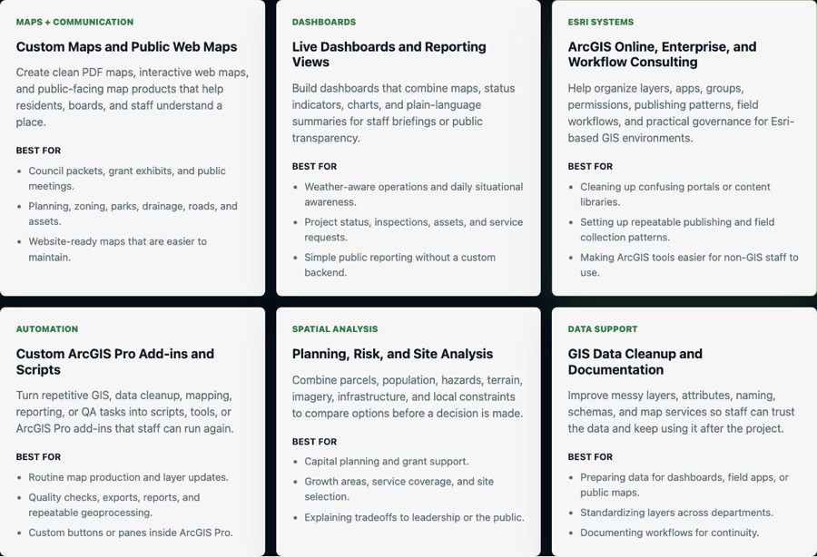
Municipal + County GIS
Support city and county work with custom maps, web maps, Esri workflows, dashboards, add-ins, and warning-system analysis.
Explore local-government services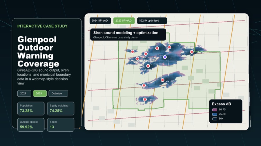
Outdoor Warning Planning
Compare SPreAD-GIS sound rasters, existing coverage, optimized placement scenarios, and budget tradeoffs on an interactive map.
Modeled $19.5k reconfiguration outperformed the documented $32.5k expansion.
Explore warning-system planning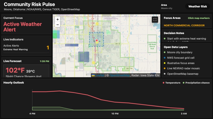
Live Dashboard Demo
A public-data dashboard turns live weather, boundaries, and local context into a plain-language briefing.
Open dashboard demo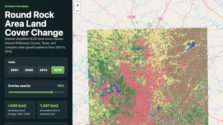
Interactive Webmap Demo
A public NLCD example turns multi-year raster data into a simple web map, chart, and decision-ready summary.
Open interactive demo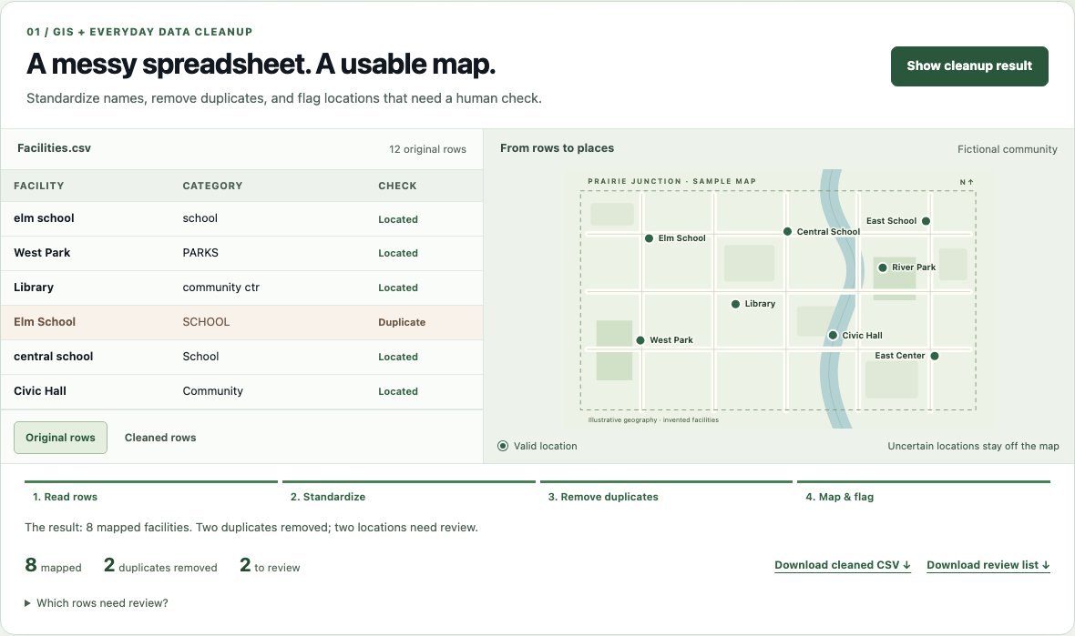
GIS Workflow Automation
Watch a spreadsheet become a map, explore simulated storm impacts, and build a briefing with working software demos.
Try the live software demosPDF Map Deliverables
Static map products are still one of the best ways to communicate boundaries, land conditions, terrain, and planning context in reports, permit packages, briefings, and public-facing materials.
 Watershed Boundary Map
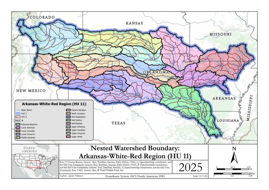
Nested basin boundaries, hydrography, locator inset, and publication layout.
Watershed Boundary Map
Nested basin boundaries, hydrography, locator inset, and publication layout.
 Land Use Classification
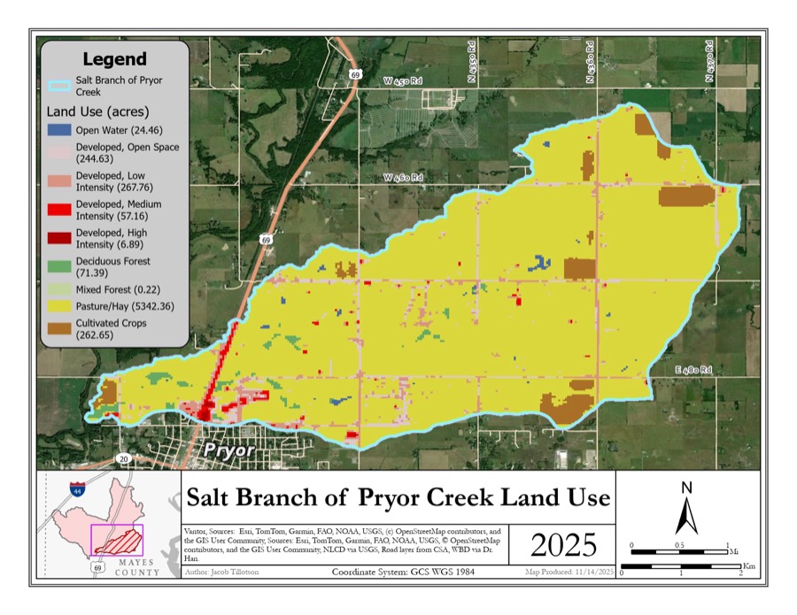
Imagery-backed land cover mapping with acreage summaries and local context.
Land Use Classification
Imagery-backed land cover mapping with acreage summaries and local context.
 Terrain & Elevation Summary
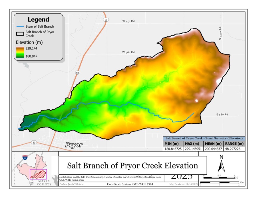
Surface modeling, elevation ranges, and watershed-scale terrain interpretation.
Terrain & Elevation Summary
Surface modeling, elevation ranges, and watershed-scale terrain interpretation.
About
Recognition
Tillotson Spatial Systems is an independent consulting practice led by Jacob Tillotson, a GIS professional specializing in spatial analysis, automation, remote sensing, weather-aware decision support, and custom geospatial tools.
The background combines professional geospatial systems work, an M.S. in Geography & Environmental Sustainability with a concentration in Geospatial Technologies, B.S. degrees in Meteorology and Geographic Information Science, and FAA Part 107 remote pilot certification.
The approach is practical: define the decision, organize the data, build the right map or tool, and explain the result in language that technical and nontechnical audiences can both trust.

Founder
GIS specialist, geospatial systems developer, and FAA Part 107 remote pilot based in Moore, Oklahoma.
FAQ
Whether you need a simple aerial photo or a technical spatial workflow, the first step is figuring out what decision the work needs to support.
Both. I can help property owners, small businesses, researchers, public agencies, and technical teams. The scope can be as simple as aerial photos of a property or as involved as GIS analysis, automation, webmaps, and decision-support tools.
Yes. I hold an FAA Part 107 remote pilot certification and can provide aerial photos and video for homes, land, buildings, listings, project sites, and general property documentation. Drone work is available across Oklahoma by project need, subject to airspace, weather, site access, and scheduling.
That is normal. You can describe the problem in plain language: what place, property, route, risk, boundary, pattern, or process you are trying to understand. I can help translate that into the right map, analysis, dataset, dashboard, or automation workflow.
Yes. PDF maps are often the right deliverable for reports, meetings, property packets, grant materials, field crews, and planning documents. I can also create webmaps when the project needs an interactive version.
Yes. I can help municipalities and counties map existing sirens, estimate outdoor sound coverage, find gaps and overlap, and compare practical options such as keeping, relocating, replacing, or adding sirens. This can support tornado warning, severe wind, flash flood, hazardous-materials, or other local outdoor-warning missions, depending on local policy. The goal is to give emergency managers clear choices before major spending decisions.
No. The technical work can include sound propagation modeling, coverage accounting, and optimization, but the deliverable should be understandable: where coverage is strong, where it is weak, what options were tested, what they cost, and what tradeoffs local leaders need to consider.
Yes. Interactive maps and dashboards are useful when people need to explore data, filter information, compare scenarios, or keep an operational view current without digging through raw files.
Yes. If you have a repeated GIS, data cleanup, reporting, file conversion, map production, or office workflow, I can often turn it into a repeatable script, tool, or small application.
My meteorology background supports weather-aware spatial work: storms, warnings, exposure, hazard planning, environmental context, and risk communication. I do not position the business as an operational weather forecasting service.
Yes. Many GIS, mapping, remote sensing, dashboard, and automation projects can be completed remotely. Drone work and some field documentation depend on location, airspace, weather, site access, and project timing.
Contact
Send a quick note about the question you are trying to answer. The first step is usually a short conversation about your data, constraints, and decision.